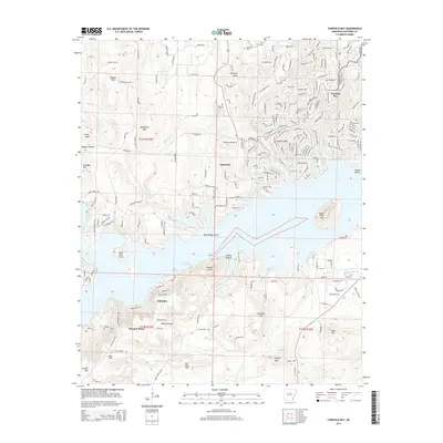
2014 Map of Fairfield Bay
USGS Topo · Published 2014About this map
Greers Ferry Lake dominates the southern half of this landscape, its indented shoreline creating numerous points and coves such as Peter Rock Point and Stevens Point. The resort community of Fairfield Bay sits on the northeast plateau, characterized by a dense network of residential streets that contrast with the more traditional settlement patterns of Eglantine and Choctaw Pines. To the north, the terrain rises into significant elevations like Bonner Mtn and Story Mtn, while Williams Rocks provides a distinctive geological landmark near the Eglantine Cem. The map reveals the intricate intersection of leisure-based development and the older rural topography of Van Buren County, with notable peaks like Sugar Loaf Mtn and the Palisades rising sharply from the water's edge.
Find a feature on this map
247 named features on this map. Tap any name to fly to it.
Don’t see what you’re looking for? This feature index may not catch every label — zoom into the map to look around manually.
Map Details
Editions of this 2014 Fairfield Bay Map
This is the sole edition of this map. No revisions or reprints were ever made.
Other maps of this area

1892 · Mountain View
USGS Topo · 1:125,000

1894 · Mountain View
USGS Topo · 1:125,000

1956 · Russellville
USGS Topo · 1:250,000

1961 · Bee Branch
USGS Topo · 1:62,500

1961 · Bee Branch
USGS Topo · 1:24,000

1961 · Morganton
USGS Topo · 1:24,000

1963 · Quitman
USGS Topo · 1:24,000

1964 · Russellville
USGS Topo · 1:250,000
1973 · Fairfield Bay
USGS Topo · 1:24,000
1973 · Greers Ferry
USGS Topo · 1:24,000