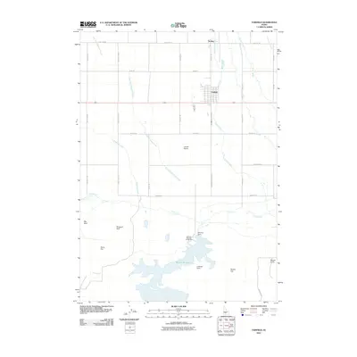
2010 Map of Fairfield
USGS Topo · Published 2010About this map
Fairfield serves as the central hub of this agricultural landscape within the wider Camas Prairie. The town’s grid is positioned north of Camas Creek, while the settlement of Soldier sits further north along Base Line Rd. Water management is a defining characteristic of the southern terrain, anchored by the expansive Mormon Reservoir and the Mormon Dam. These water resources support the surrounding ranching and farming operations on Davis Flat and Squaw Flat.
Find a feature on this map
34 named features on this map. Tap any name to fly to it.
Don’t see what you’re looking for? This feature index may not catch every label — zoom into the map to look around manually.
Map Details
Editions of this 2010 Fairfield Map
This is the sole edition of this map. No revisions or reprints were ever made.
Other maps of this area

1955 · Hailey
USGS Topo · 1:250,000

1957 · Fairfield
USGS Topo · 1:62,500

1957 · Thorn Creek
USGS Topo · 1:62,500

1957 · Davis Mountain
USGS Topo · 1:62,500

1957 · Blaine
USGS Topo · 1:62,500

1959 · Hailey
USGS Topo · 1:250,000

1962 · Hailey
USGS Topo · 1:250,000
1986 · Phillips
USGS Topo · 1:24,000
1986 · Fir Grove Mountain
USGS Topo · 1:24,000
1986 · Corral
USGS Topo · 1:24,000