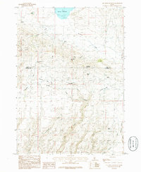
1986 Map of Fir Grove Mountain
USGS Topo · Published 1986About this map
City of Rocks dominates the southern landscape of this 1986 survey, marking a geologically complex region along the border of Camas and Gooding counties. The terrain is defined by a dense network of hydrologic features and high-altitude landmarks, most notably Mormon Reservoir in the north and the prominent peak of Fir Grove Mountain. This era of the Idaho backcountry shows a reliance on dispersed water sources, with numerous named springs such as Simms Spring, Cow Heaven Spring, and Big Mike Spring providing vital points of reference for land use and navigation.
Find a feature on this map
28 named features on this map. Tap any name to fly to it.
Don’t see what you’re looking for? This feature index may not catch every label — zoom into the map to look around manually.
Map Details
Editions of this 1986 Fir Grove Mountain Map
This is the sole edition of this map. No revisions or reprints were ever made.
Other maps of this area

1955 · Hailey
USGS Topo · 1:250,000

1957 · Fairfield
USGS Topo · 1:62,500

1957 · Thorn Creek SW
USGS Topo · 1:24,000

1957 · Thorn Creek
USGS Topo · 1:62,500

1957 · Davis Mountain
USGS Topo · 1:62,500

1957 · Blaine
USGS Topo · 1:62,500

1959 · Hailey
USGS Topo · 1:250,000

1962 · Hailey
USGS Topo · 1:250,000
1986 · Mc Kinney Butte
USGS Topo · 1:24,000
1986 · Corral
USGS Topo · 1:24,000