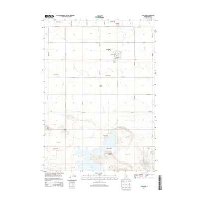
2013 Map of Fairfield
USGS Topo · Published 2013About this map
Fairfield and the nearby settlement of Soldier anchor this high-plains landscape in Camas County, captured during a period of modern agricultural and recreational use. The terrain is defined by the expanse of the Camas Prairie, which transitions from the flatlands of Davis Flat and Squaw Flat into the prominent rises of Big Bluff, Windmill Bluff, and Lookout Point. Hydrology is a central theme, with the waters of Camas Cr and Soldier Cr flowing toward the Mormon Reservoir, a significant local landmark equipped with a designated Mormon Reservoir Access Area. The map also documents the local aviation infrastructure at the Camas County Airport, situated just south of the main Fairfield township. A grid of rural routes, such as Manard RD and Wylder RD, illustrates the organized settlement pattern of the region, while smaller drainages like E Fork Threemile Cr and Minear Cr provide fine-grained detail of the drainage system north of the reservoir.
Find a feature on this map
48 named features on this map. Tap any name to fly to it.
Don’t see what you’re looking for? This feature index may not catch every label — zoom into the map to look around manually.
Map Details
Editions of this 2013 Fairfield Map
This is the sole edition of this map. No revisions or reprints were ever made.
Other maps of this area

1955 · Hailey
USGS Topo · 1:250,000

1957 · Fairfield
USGS Topo · 1:62,500

1957 · Thorn Creek
USGS Topo · 1:62,500

1957 · Davis Mountain
USGS Topo · 1:62,500

1957 · Blaine
USGS Topo · 1:62,500

1959 · Hailey
USGS Topo · 1:250,000

1962 · Hailey
USGS Topo · 1:250,000
1986 · Phillips
USGS Topo · 1:24,000
1986 · Fir Grove Mountain
USGS Topo · 1:24,000
1986 · Corral
USGS Topo · 1:24,000