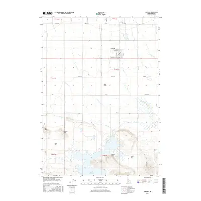
2017 Map of Fairfield
USGS Topo · Published 2017About this map
Fairfield serves as the central hub of this agricultural landscape, situated within the expansive Camas Prairie just south of the historic settlement of Soldier. The layout of the town reveals a clear grid system including Sage Ave W and Alturas Ave W, supporting the local community and the nearby Camas County Airport. The terrain shifts significantly from the level prairie in the north to a complex network of bluffs and flats in the south, where the waters of Camas Cr flow toward the large Mormon Reservoir. Landmarks like Big Bluff, Windmill Bluff, and Lookout Point provide distinct topographic relief against the surrounding lowlands of Davis Flat and Squaw Flat. This 2017 survey documents a modern snapshot of the county seat, where the economy remains closely tied to the water resources provided by Threemile Cr and Soldier Cr.
Find a feature on this map
42 named features on this map. Tap any name to fly to it.
Don’t see what you’re looking for? This feature index may not catch every label — zoom into the map to look around manually.
Map Details
Editions of this 2017 Fairfield Map
This is the sole edition of this map. No revisions or reprints were ever made.
Other maps of this area

1955 · Hailey
USGS Topo · 1:250,000

1957 · Fairfield
USGS Topo · 1:62,500

1957 · Thorn Creek
USGS Topo · 1:62,500

1957 · Davis Mountain
USGS Topo · 1:62,500

1957 · Blaine
USGS Topo · 1:62,500

1959 · Hailey
USGS Topo · 1:250,000

1962 · Hailey
USGS Topo · 1:250,000
1986 · Phillips
USGS Topo · 1:24,000
1986 · Fir Grove Mountain
USGS Topo · 1:24,000
1986 · Corral
USGS Topo · 1:24,000