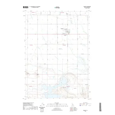
2020 Map of Fairfield
USGS Topo · Published 2020About this map
Fairfield serves as the focal point of this Idaho landscape, anchored by the Camas County Courthouse and providing a gateway to the high plains. North of town, the settlement of Soldier sits along Soldier Cr, while the Camas County Airport and a network of agricultural roads like Wylder Rd and Manard Rd define the local infrastructure. The terrain is characterized by the broad expanse of the Camas Prairie, interrupted by distinctive topographical markers such as Big Bluff, Windmill Bluff, and Lookout Point.
Find a feature on this map
42 named features on this map. Tap any name to fly to it.
Don’t see what you’re looking for? This feature index may not catch every label — zoom into the map to look around manually.
Map Details
Editions of this 2020 Fairfield Map
This is the sole edition of this map. No revisions or reprints were ever made.
Other maps of this area

1955 · Hailey
USGS Topo · 1:250,000

1957 · Fairfield
USGS Topo · 1:62,500

1957 · Thorn Creek
USGS Topo · 1:62,500

1957 · Davis Mountain
USGS Topo · 1:62,500

1957 · Blaine
USGS Topo · 1:62,500

1959 · Hailey
USGS Topo · 1:250,000

1962 · Hailey
USGS Topo · 1:250,000
1986 · Phillips
USGS Topo · 1:24,000
1986 · Fir Grove Mountain
USGS Topo · 1:24,000
1986 · Corral
USGS Topo · 1:24,000