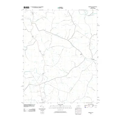
2010 Map of Fairfield
USGS Topo · Published 2010About this map
Fairfield anchors this landscape in northern Nelson County, where the topography is defined by an intricate network of waterways draining toward the Salt River. The drainage pattern is particularly dense, with East Fork Cox Creek, Kimbly Run, and Plum Run carving the terrain into a series of ridges and valleys. This 2010 survey reflects a rural infrastructure built upon long-established family routes and regional connectors, including Irish Ridge Rd and Mobley Mill Rd. Local heritage is anchored at sites like Saint Michaels Cemetery and Montgomery Cemetery, which sit among the undulating hills. The proximity of Simpson Creek in the northeast and Samuels Creek in the southwest illustrates the significant role these small watercourses play in defining property boundaries and local orientation in this part of Kentucky.
Find a feature on this map
37 named features on this map. Tap any name to fly to it.
Don’t see what you’re looking for? This feature index may not catch every label — zoom into the map to look around manually.
Map Details
Editions of this 2010 Fairfield Map
This is the sole edition of this map. No revisions or reprints were ever made.
Other maps of this area

1907 · Louisville
USGS Topo · 1:62,500

1929 · Taylorsville
USGS Topo · 1:62,500

1949 · Cravens
USGS Topo · 1:24,000

1949 · Samuels
USGS Topo · 1:24,000

1949 · Shepherdsville
USGS Topo · 1:62,500

1951 · Waterford
USGS Topo · 1:24,000

1951 · Mount Washington
USGS Topo · 1:24,000
1951 · Louisville
USGS Topo · 1:62,500

1953 · Maud
USGS Topo · 1:24,000

1953 · Bardstown
USGS Topo · 1:24,000