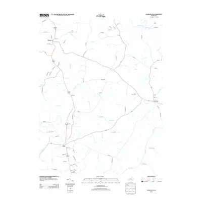
2013 Map of Fairfield
USGS Topo · Published 2013About this map
The Salt River and its numerous tributaries, including Simpson Cr and Bowman Cr, define the drainage patterns of this Nelson County landscape. This 2013 survey illustrates the rural character of central Kentucky, centered on the historic crossroads of Fairfield and the neighboring settlements of Highgrove and Coxs Creek. The map provides specific locations for local heritage sites like Saint Michaels Cem and Montgomery Cem, which are essential for genealogical research in this region. The terrain is characterized by a dense network of watercourses such as E Fork Cox Cr, Kimbly Run, and Plum Run, while the road system reflects long-standing property lines and local family names, including Murrays Run Rd and Will Scott Snyder Rd. This map is a precise record of the contemporary rural infrastructure and natural drainage before further modern development.
Find a feature on this map
71 named features on this map. Tap any name to fly to it.
Don’t see what you’re looking for? This feature index may not catch every label — zoom into the map to look around manually.
Map Details
Editions of this 2013 Fairfield Map
This is the sole edition of this map. No revisions or reprints were ever made.
Other maps of this area

1907 · Louisville
USGS Topo · 1:62,500

1929 · Taylorsville
USGS Topo · 1:62,500

1949 · Cravens
USGS Topo · 1:24,000

1949 · Samuels
USGS Topo · 1:24,000

1949 · Shepherdsville
USGS Topo · 1:62,500

1951 · Waterford
USGS Topo · 1:24,000

1951 · Mount Washington
USGS Topo · 1:24,000
1951 · Louisville
USGS Topo · 1:62,500

1953 · Maud
USGS Topo · 1:24,000

1953 · Bardstown
USGS Topo · 1:24,000