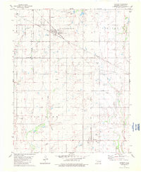
1982 Map of Fairmont
USGS Topo · Published 1983About this map
Industrial energy production and rail logistics define this central Oklahoma landscape at the start of the 1980s. The town of Fairmont serves as a nexus for two major rail lines, the Burlington Northern and the Atchison Topeka and Santa Fe, which cut across a terrain dominated by significant extraction operations. Massive subterranean resources are mapped as the Patterson Gas Field in the north and the extensive Skeleton Oil and Gas Field in the south, interspersed with numerous active Oil and Gas Wells and several Shale Pits. Amidst this industrial infrastructure, traditional rural markers remain, including Zion Cem, Collett Cem, and Union Cem. Waterways like Bitter Creek and Wolf Creek meander through the grid-iron section lines, providing a natural contrast to the geometric precision of the Pipeline corridors and corporate boundaries such as the Fairmont Corp Bdy.
Find a feature on this map
22 named features on this map. Tap any name to fly to it.
Don’t see what you’re looking for? This feature index may not catch every label — zoom into the map to look around manually.
Map Details
Editions of this 1982 Fairmont Map
This is the sole edition of this map. No revisions or reprints were ever made.
Other maps of this area

1893 · Lovell
USGS Topo · 1:62,500

1893 · Hennessey
USGS Topo · 1:62,500

1955 · Enid East
USGS Topo · 1:24,000

1955 · Enid
USGS Topo · 1:250,000

1956 · Garber
USGS Topo · 1:62,500

1956 · Hennessey
USGS Topo · 1:62,500

1956 · Enid
USGS Topo · 1:62,500

1958 · Enid
USGS Topo · 1:250,000

1974 · Marshall West
USGS Topo · 1:24,000

1974 · Marshall East
USGS Topo · 1:24,000