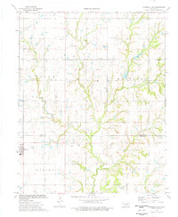
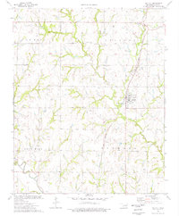
1974 Map of Marshall East
USGS Topo · Published 1977About this map
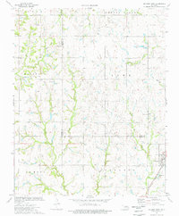
Marshall serves as the primary hub of activity in this northern Oklahoma landscape, situated near the southwestern edge of the quadrangle. The terrain is defined by a dense network of watercourses, including Otter Creek and Crows Nest Creek, which cut through the agricultural and industrial landscape. The map reveals a region heavily shaped by petroleum extraction, with several Oil Field notations and specific sites such as an Oil Well and a Drill Hole indicating the energy production that dominated the local economy during the mid-1970s.
Find a feature on this map
17 named features on this map. Tap any name to fly to it.
Don’t see what you’re looking for? This feature index may not catch every label — zoom into the map to look around manually.
Map Details
Editions of this 1974 Marshall East Map
This is the sole edition of this map. No revisions or reprints were ever made.
Other maps of this area
1893 · Mulhall
USGS Topo · 1:62,500
1893 · Lovell
USGS Topo · 1:62,500

1955 · Enid
USGS Topo · 1:250,000
1956 · Garber
USGS Topo · 1:62,500

1958 · Enid
USGS Topo · 1:250,000
1972 · Lucien
USGS Topo · 1:24,000
1974 · Mulhall
USGS Topo · 1:24,000
1974 · Marshall West
USGS Topo · 1:24,000
1974 · Bridge Creek
USGS Topo · 1:24,000
1974 · Orlando West
USGS Topo · 1:24,000