
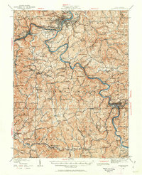
1923 Map of Fairmont
USGS Topo · Published 1956About this map
The industrial and river geography of North Central West Virginia is prominently displayed along the Monongahela River and Tygart River corridors. The hub of Fairmont serves as a focal point, where the Baltimore and Ohio RR network facilitates the region's coal and transit economy. Extensive rural development is evidenced by the high density of country schools and houses of worship, such as Hickman Run School and the Jane Memorial Church.
Find a feature on this map
196 named features on this map. Tap any name to fly to it.
Don’t see what you’re looking for? This feature index may not catch every label — zoom into the map to look around manually.
Map Details
Editions of this 1923 Fairmont Map
2 editions found
Other maps of this area

1886 · St. George
USGS Topo · 1:125,000

1891 · St. George
USGS Topo · 1:125,000

1902 · Clarksburg
USGS Topo · 1:62,500

1902 · Fairmont
USGS Topo · 1:62,500

1902 · Morgantown
USGS Topo · 1:62,500

1904 · Philippi
USGS Topo · 1:62,500

1904 · Blacksville
USGS Topo · 1:62,500

1904 · Weston
USGS Topo · 1:62,500

1905 · Mannington
USGS Topo · 1:62,500

1907 · Thornton
USGS Topo · 1:62,500