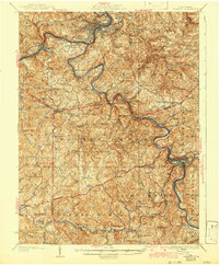
1926 Map of Fairmont
USGS Topo · Published 1942About this map
The Monongahela River and Tygart River define this industrial and coal-producing corridor of West Virginia as it appeared in the early twentieth century. Extensive rail infrastructure from the Baltimore and Ohio railroad supports industrial operations like the Tyconnell Mines and allows for the growth of concentrated settlements such as Fairmont, Grafton, and Monongah. Beyond the river valleys, the landscape is densely dotted with rural social centers, including numerous schools like the Mud Lick School and White Rock School, alongside congregations at Nebo Church and Elizabeth Chapel. The presence of the Northwestern Turnpike crossing the lower portion of the sheet near Bridgeport highlights the convergence of nineteenth-century overland routes with the newer industrial rail economy. The survey documents many smaller villages like Wendell and Fetterman that were vital to the region's early development.
Find a feature on this map
161 named features on this map. Tap any name to fly to it.
Don’t see what you’re looking for? This feature index may not catch every label — zoom into the map to look around manually.
Map Details
Editions of this 1926 Fairmont Map
3 editions found

Other maps of this area

1886 · St. George
USGS Topo · 1:125,000

1891 · St. George
USGS Topo · 1:125,000

1902 · Clarksburg
USGS Topo · 1:62,500

1902 · Fairmont
USGS Topo · 1:62,500

1902 · Morgantown
USGS Topo · 1:62,500

1904 · Philippi
USGS Topo · 1:62,500

1904 · Blacksville
USGS Topo · 1:62,500

1904 · Weston
USGS Topo · 1:62,500

1905 · Mannington
USGS Topo · 1:62,500

1907 · Thornton
USGS Topo · 1:62,500