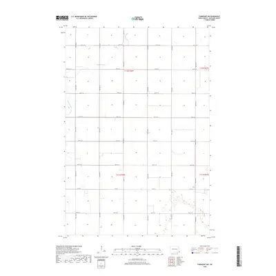
2018 Map of Fairmount NW
USGS Topo · Published 2018About this map
The Wild Rice River meanders through the northern sections of this rural Richland County landscape, defining the topography of an area dominated by precise agricultural partitioning. Surveyed in 2018, the landscape is organized by a rigorous grid of section lines and gravel roads, including the east-west corridor of Co Rd 16. The transition between townships like t132n r48w and t131n r48w highlights the enduring Public Land Survey System structure that has governed North Dakota land ownership since the nineteenth century. While few structures are named, the layout of numbered avenues such as 177th Ave SE and 180th Ave SE provides a clear framework for genealogists or local historians tracing family farmsteads and field boundaries across these prairie reaches.
Find a feature on this map
19 named features on this map. Tap any name to fly to it.
Don’t see what you’re looking for? This feature index may not catch every label — zoom into the map to look around manually.
Map Details
Editions of this 2018 Fairmount NW Map
This is the sole edition of this map. No revisions or reprints were ever made.
Other maps of this area

1904 · Wahpeton
USGS Topo · 1:125,000

1953 · Fargo
USGS Topo · 1:250,000

1956 · Fargo
USGS Topo · 1:250,000

1960 · Mooreton East
USGS Topo · 1:24,000

1964 · Fairmount NW
USGS Topo · 1:24,000

1964 · Hankinson SE
USGS Topo · 1:24,000

1964 · Great Bend
USGS Topo · 1:24,000

1964 · Dwight
USGS Topo · 1:24,000

1964 · Wahpeton
USGS Topo · 1:24,000
1972 · Sonora
USGS Topo · 1:24,000