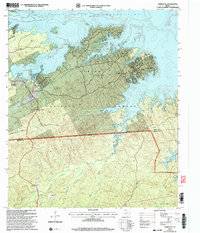
2003 Map of Fairmount
USGS Topo · Published 2004About this map
Sabine National Forest dominates the landscape of this East Texas survey, where the dense timberlands meet the extensive shoreline of the Toledo Bend Reservoir. This era shows a community shaped by both recreational access and long-standing rural roots, with the settlement of Fairmount and the residential developments at Hickory Ridge and Magees Landing taking advantage of the reservoir's deeply indented coves. Inland, the terrain rises toward local heights like Mount Sinai and Fox Hunters Hill. Genealogists and local historians can locate several important cultural markers, including the Mt Sinai Cem near the Fairdale Missionary Ch, and the more remote Weaver Cem situated near the headwaters of Mill Creek. The map also captures the Sabine Co Newton Co line as it cuts through the sandy hills south of the reservoir.
Find a feature on this map
33 named features on this map. Tap any name to fly to it.
Don’t see what you’re looking for? This feature index may not catch every label — zoom into the map to look around manually.
Map Details
Editions of this 2003 Fairmount Map
This is the sole edition of this map. No revisions or reprints were ever made.
Other maps of this area

1944 · Negreet
USGS Topo · 1:62,500

1944 · Wiergate
USGS Topo · 1:62,500

1948 · Wiergate
USGS Topo · 1:62,500

1953 · Alexandria
USGS Topo · 1:250,000

1954 · Wiergate
USGS Topo · 1:24,000

1954 · Toro
USGS Topo · 1:24,000

1954 · Wiergate SE
USGS Topo · 1:24,000

1954 · Columbus
USGS Topo · 1:24,000

1954 · Fairdale
USGS Topo · 1:24,000

1954 · Negreet
USGS Topo · 1:62,500