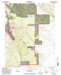
1994 Map of Fairplay West
USGS Topo · Published 1998About this map
High-altitude mining and timber heritage defines this portion of the Pike National Forest in the 1990s. The landscape is a mosaic of early industrial efforts, marked by numerous former settlements such as Holland, Sacramento, and Mullenville. The density of these sites, alongside the Duquesne Smelter, suggests a once-active corridor of ore processing and extraction that had largely transitioned back to forest management by this era.
Find a feature on this map
51 named features on this map. Tap any name to fly to it.
Don’t see what you’re looking for? This feature index may not catch every label — zoom into the map to look around manually.
Map Details
Editions of this 1994 Fairplay West Map
This is the sole edition of this map. No revisions or reprints were ever made.
Other maps of this area

1889 · Leadville
USGS Topo · 1:125,000

1891 · Leadville
USGS Topo · 1:125,000

1934 · Climax
USGS Topo · 1:48,000

1937 · Como
USGS Topo · 1:62,500

1938 · Mt. Lincoln
USGS Topo · 1:48,000

1942 · Leadville
USGS Topo · 1:125,000

1945 · Mount Lincoln
USGS Topo · 1:62,500

1953 · Denver
USGS Topo · 1:250,000

1956 · Garo
USGS Topo · 1:24,000

1956 · Fairplay East
USGS Topo · 1:24,000