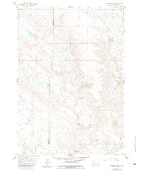
1959 Map of Fairpoint NW
USGS Topo · Published 1983About this map
Elm Butte rises as a prominent landmark above the drainages of the South Dakota plains in this late-1950s survey. The landscape is defined by its seasonal hydrology, where several named waterways converge and diverge across the rangeland. The map illustrates the meandering paths of Plum Creek and Soft Water Creek as they traverse the eastern portion of the quadrangle. Along the western edge, the headwaters of Crooked Creek and the branching segments of Elm Creek trace the natural contours of the land. This survey also documents the geopolitical boundary between Butte Co and Meade Co, showing how the survey line cuts directly across the drainage basins. The lack of concentrated settlements or structures highlights the open, rural character of the region during this era, focused primarily on the topography of the creek beds and local buttes.
Find a feature on this map
6 named features on this map. Tap any name to fly to it.
Don’t see what you’re looking for? This feature index may not catch every label — zoom into the map to look around manually.
Map Details
Editions of this 1959 Fairpoint NW Map
2 editions found
Other maps of this area

1913 · Newell
USGS Topo · 1:125,000

1951 · Volunteer SE
USGS Topo · 1:24,000

1953 · Rapid City
USGS Topo · 1:250,000

1957 · Rapid City
USGS Topo · 1:250,000

1959 · Fairpoint
USGS Topo · 1:24,000

1959 · Fairpoint SW
USGS Topo · 1:24,000
1959 · Volunteer NE
USGS Topo · 1:24,000

1959 · Fairpoint NW
USGS Topo · 1:24,000
1959 · Fairpoint SE
USGS Topo · 1:24,000

1977 · Table Top Butte
USGS Topo · 1:24,000