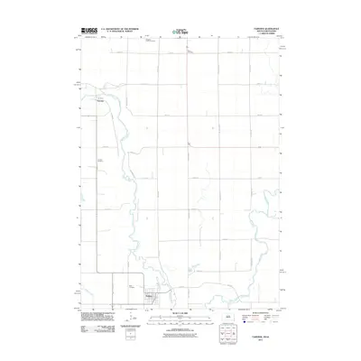
2011 Map of Fairview
USGS Topo · Published 2011About this map
Hudson and Fairview anchor this survey along the winding border between South Dakota and Iowa. The Big Sioux River creates a serpentine boundary through the center of the sheet, joined in the south by the Rock River and Pattee Creek. The landscape is defined by a rigorous grid of section-line roads, including Cherry Ave and 300th St, which connect small communities to the surrounding farmland. Genealogists will find several burial sites noted across the rural townships, from the Eden Cemetery near Hudson to the more remote Bragstad Family Cemetery and Sioux Cemetery in the north. The proximity of these two rivers and their floodplains highlights the importance of the river-valley topography in shaping the regional settlement pattern and road network.
Find a feature on this map
30 named features on this map. Tap any name to fly to it.
Don’t see what you’re looking for? This feature index may not catch every label — zoom into the map to look around manually.
Map Details
Editions of this 2011 Fairview Map
This is the sole edition of this map. No revisions or reprints were ever made.
Other maps of this area

1897 · Canton
USGS Topo · 1:125,000

1900 · Canton
USGS Topo · 1:125,000

1955 · Sioux Falls
USGS Topo · 1:250,000

1958 · Sioux Falls
USGS Topo · 1:250,000

1962 · Canton
USGS Topo · 1:24,000

1968 · Alcester NE
USGS Topo · 1:24,000
1968 · Alcester SE
USGS Topo · 1:24,000
1968 · Hawarden North
USGS Topo · 1:24,000

1968 · Fairview
USGS Topo · 1:24,000

1968 · Labanon
USGS Topo · 1:24,000