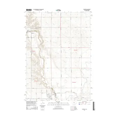
2015 Map of Fairview
USGS Topo · Published 2015About this map
The Big Sioux River snakes through the heart of this border region, defining the boundary between Lincoln County, South Dakota, and Sioux County, Iowa. The small settlements of Fairview and Hudson anchor the southern reaches of the map, connected by a network of rural roads that follow the township and range lines. The terrain is characterized by the convergence of the Rock River with the Big Sioux River just east of Hudson.
Find a feature on this map
41 named features on this map. Tap any name to fly to it.
Don’t see what you’re looking for? This feature index may not catch every label — zoom into the map to look around manually.
Map Details
Editions of this 2015 Fairview Map
This is the sole edition of this map. No revisions or reprints were ever made.
Other maps of this area

1897 · Canton
USGS Topo · 1:125,000

1900 · Canton
USGS Topo · 1:125,000

1955 · Sioux Falls
USGS Topo · 1:250,000

1958 · Sioux Falls
USGS Topo · 1:250,000

1962 · Canton
USGS Topo · 1:24,000

1968 · Alcester NE
USGS Topo · 1:24,000
1968 · Alcester SE
USGS Topo · 1:24,000
1968 · Hawarden North
USGS Topo · 1:24,000

1968 · Fairview
USGS Topo · 1:24,000

1968 · Labanon
USGS Topo · 1:24,000