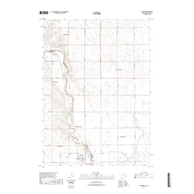
2017 Map of Fairview
USGS Topo · Published 2017About this map
The Big Sioux River serves as a winding natural boundary between South Dakota and Iowa, defining the western edge of this 2017 survey. The town of Fairview sits nestled in a bend of the river, while Hudson anchors the southern portion of the map. This area is characterized by a high concentration of cemeteries including Eden Cem, Fairview Cem, and Sioux Cem, which reflect the early pioneer settlement patterns along the fertile river valley.
Find a feature on this map
51 named features on this map. Tap any name to fly to it.
Don’t see what you’re looking for? This feature index may not catch every label — zoom into the map to look around manually.
Map Details
Editions of this 2017 Fairview Map
This is the sole edition of this map. No revisions or reprints were ever made.
Other maps of this area

1897 · Canton
USGS Topo · 1:125,000

1900 · Canton
USGS Topo · 1:125,000

1955 · Sioux Falls
USGS Topo · 1:250,000

1958 · Sioux Falls
USGS Topo · 1:250,000

1962 · Canton
USGS Topo · 1:24,000

1968 · Alcester NE
USGS Topo · 1:24,000
1968 · Alcester SE
USGS Topo · 1:24,000
1968 · Hawarden North
USGS Topo · 1:24,000

1968 · Fairview
USGS Topo · 1:24,000

1968 · Labanon
USGS Topo · 1:24,000