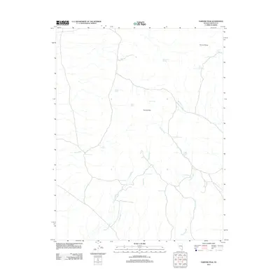
2012 Map of Fairview Peak
USGS Topo · Published 2012About this map
Fairview Peak stands as the central landmark in this corner of Lincoln County, where the high desert terrain is defined by an intricate network of seasonal drainage and scattered water sources. The Fairview Range dominates the northeastern section, while the landscape below is carved by Bob Hamilton Wash, Fairview Wash, and Silverhorn Wash. These ephemeral watercourses are vital markers in an arid environment, often punctuated by isolated springs that have historically served as critical stops for travelers and livestock.
Find a feature on this map
23 named features on this map. Tap any name to fly to it.
Don’t see what you’re looking for? This feature index may not catch every label — zoom into the map to look around manually.
Map Details
Editions of this 2012 Fairview Peak Map
This is the sole edition of this map. No revisions or reprints were ever made.
Other maps of this area

1915 · Bristol Range
USGS Topo · 1:62,500

1917 · Bristol Range
USGS Topo · 1:62,500

1953 · Bristol Range SE
USGS Topo · 1:24,000

1956 · Lund
USGS Topo · 1:250,000

1960 · Lund
USGS Topo · 1:250,000
1971 · Bristol Well
USGS Topo · 1:24,000
1971 · Bristol Range NE
USGS Topo · 1:24,000

1971 · Bailey Wash
USGS Topo · 1:24,000
1971 · Fairview Peak
USGS Topo · 1:24,000

1971 · Sidehill Pass
USGS Topo · 1:24,000