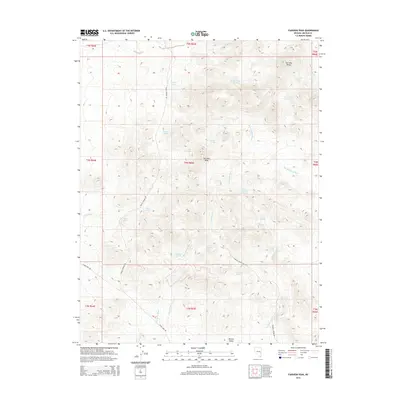
2015 Map of Fairview Peak
USGS Topo · Published 2015About this map
Fairview Peak stands as the central high point in this remote corner of Lincoln County, where the high desert terrain is defined by a critical network of springs and dry washes. The landscape transitions from the heights of the Fairview Range into the broad expanse of Bristol Valley to the south. Life in this arid environment revolves around seasonal water sources and historical transit routes like Bailey Springs Rd and Silver King Rd. The map reveals a high concentration of named water points including Hornsilver Spring, Fox Cabin Spring, and the tiered Upper Fairview Spring and Lower Fairview Spring. These features, along with the numerous washes like Bob Hamilton Wash and Hornsilver Wash, illustrate the hydrological patterns and topographic challenges faced by ranchers and travelers moving through the Great Basin.
Find a feature on this map
37 named features on this map. Tap any name to fly to it.
Don’t see what you’re looking for? This feature index may not catch every label — zoom into the map to look around manually.
Map Details
Editions of this 2015 Fairview Peak Map
This is the sole edition of this map. No revisions or reprints were ever made.
Other maps of this area

1915 · Bristol Range
USGS Topo · 1:62,500

1917 · Bristol Range
USGS Topo · 1:62,500

1953 · Bristol Range SE
USGS Topo · 1:24,000

1956 · Lund
USGS Topo · 1:250,000

1960 · Lund
USGS Topo · 1:250,000
1971 · Bristol Well
USGS Topo · 1:24,000
1971 · Bristol Range NE
USGS Topo · 1:24,000

1971 · Bailey Wash
USGS Topo · 1:24,000
1971 · Fairview Peak
USGS Topo · 1:24,000

1971 · Sidehill Pass
USGS Topo · 1:24,000