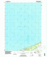
1996 Map of Fairview SW
USGS Topo · Published 1996About this map
Lake Erie dominates this coastal survey, where the shoreline of Springfield and Girard meets the water at an elevation of 572 feet. The landscape is defined by the steep bluffs and ravines characteristic of the Erie County lakefront, with narrow roads like Holliday Road and Crooked Road navigating the immediate coastal shelf.
Find a feature on this map
11 named features on this map. Tap any name to fly to it.
Don’t see what you’re looking for? This feature index may not catch every label — zoom into the map to look around manually.
Map Details
Editions of this 1996 Fairview SW Map
This is the sole edition of this map. No revisions or reprints were ever made.
Other maps of this area

1900 · Girard
USGS Topo · 1:62,500

1900 · Fairview
USGS Topo · 1:62,500

1906 · Conneaut
USGS Topo · 1:62,500

1950 · Cleveland
USGS Topo · 1:250,000

1950 · Erie
USGS Topo · 1:250,000

1956 · Cleveland
USGS Topo · 1:250,000

1957 · Fairview SW
USGS Topo · 1:24,000
1957 · Fairview
USGS Topo · 1:24,000

1959 · East Springfield
USGS Topo · 1:24,000
1959 · Albion
USGS Topo · 1:24,000