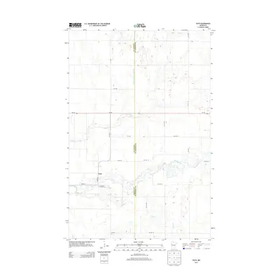
2013 Map of Faith
USGS Topo · Published 2013About this map
Faith sits at the intersection of Co Hwy-40 and Co Hwy-29, serving as a primary point of settlement in this rural pocket of northwestern Minnesota. The landscape is defined by the winding course of the Wild Rice River and its tributaries, including Marsh Cr and Spring Cr, which carve through the prairie terrain. The border between Norman Co and Mahnomen Co bisects the region, where a geometric grid of township roads like Twp Hwy 79 and Twp Hwy 101 overlays the natural hydrology. Genealogists will find the Saint Olaf Lutheran Cem south of the main settlement, a significant landmark for tracing local family history in this agricultural community. The presence of the Judicial Ditch Number Fiftyfive further north illustrates the early 21st-century water management systems essential for the surrounding farmland.
Find a feature on this map
24 named features on this map. Tap any name to fly to it.
Don’t see what you’re looking for? This feature index may not catch every label — zoom into the map to look around manually.
Map Details
Editions of this 2013 Faith Map
This is the sole edition of this map. No revisions or reprints were ever made.
Other maps of this area

1918 · Flom
USGS Topo · 1:62,500

1952 · Grand Forks
USGS Topo · 1:250,000

1954 · Bemidji
USGS Topo · 1:250,000

1956 · Grand Forks
USGS Topo · 1:250,000

1957 · Bemidji
USGS Topo · 1:250,000

1958 · Bemidji
USGS Topo · 1:250,000

1965 · Waukon
USGS Topo · 1:24,000

1966 · Flom
USGS Topo · 1:24,000

1966 · Grand Forks
USGS Topo · 1:250,000
1966 · Flom NE
USGS Topo · 1:24,000