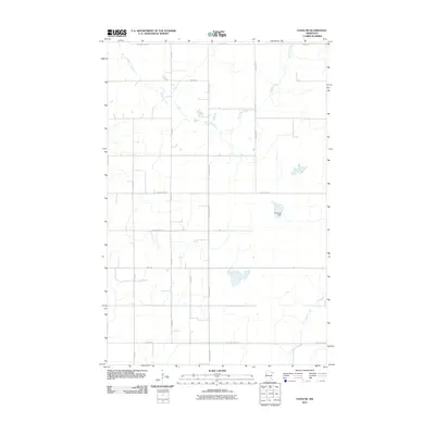
2011 Map of Faith NE
USGS Topo · Published 2011About this map
The Sand Hill River meanders across this rural section of Polk County, defining the drainage patterns of an agricultural landscape structured by a precise grid of county highways and section roads. This early 21st-century survey shows a terrain dominated by water management and land division, where features like the Frog Lake Dam represent localized efforts to control the flow toward the Red River Valley. In the southeastern portion of the map, Marsh Creek cuts through the plains, while arterial routes such as County Hwy-107 and County Hwy-42 provide the primary infrastructure connecting isolated farmsteads and township lands. The distribution of small wetlands and drainage channels among the numbered section roads reveals the persistent challenge of managing water in this low-relief prairie environment.
Find a feature on this map
23 named features on this map. Tap any name to fly to it.
Don’t see what you’re looking for? This feature index may not catch every label — zoom into the map to look around manually.
Map Details
Editions of this 2011 Faith NE Map
This is the sole edition of this map. No revisions or reprints were ever made.
Other maps of this area

1919 · Valley
USGS Topo · 1:62,500

1952 · Grand Forks
USGS Topo · 1:250,000

1954 · Bemidji
USGS Topo · 1:250,000

1956 · Grand Forks
USGS Topo · 1:250,000

1957 · Bemidji
USGS Topo · 1:250,000

1958 · Bemidji
USGS Topo · 1:250,000

1965 · Waukon
USGS Topo · 1:24,000

1966 · Grand Forks
USGS Topo · 1:250,000
1966 · Halverson Lake
USGS Topo · 1:24,000

1966 · Union Lake
USGS Topo · 1:24,000