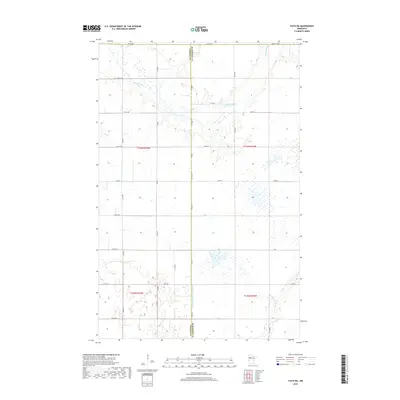
2019 Map of Faith NE
USGS Topo · Published 2019About this map
The Sand Hill River meanders through this portion of the northern plains, creating a distinct riparian corridor amidst a heavily gridded agricultural landscape. This 2019 survey documents the complex water management systems of the region, featuring the prominent Judicial Ditch Number Fiftyfive which runs south toward the border shared by Mahnomen Co and Norman Co. The landscape is defined by its transition from the river's natural curves to the engineered precision of drainage canals like Marsh Cr. The infrastructure of the area relies on a strict network of section-line roads, including Co Hwy 178 and several numbered county routes such as Co Rd 9 and Co Rd 133, which facilitate the movement of goods through these remote townships.
Find a feature on this map
26 named features on this map. Tap any name to fly to it.
Don’t see what you’re looking for? This feature index may not catch every label — zoom into the map to look around manually.
Map Details
Editions of this 2019 Faith NE Map
This is the sole edition of this map. No revisions or reprints were ever made.
Other maps of this area

1919 · Valley
USGS Topo · 1:62,500

1952 · Grand Forks
USGS Topo · 1:250,000

1954 · Bemidji
USGS Topo · 1:250,000

1956 · Grand Forks
USGS Topo · 1:250,000

1957 · Bemidji
USGS Topo · 1:250,000

1958 · Bemidji
USGS Topo · 1:250,000

1965 · Waukon
USGS Topo · 1:24,000

1966 · Grand Forks
USGS Topo · 1:250,000
1966 · Halverson Lake
USGS Topo · 1:24,000

1966 · Union Lake
USGS Topo · 1:24,000