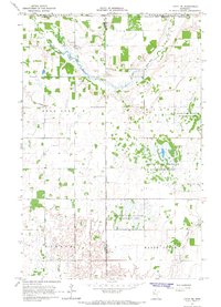
1966 Map of Faith NE
USGS Topo · Published 1967About this map
The White Earth Indian Reservation Boundary bisects this landscape, marking a significant jurisdictional division in northwestern Minnesota during the mid-1960s. The terrain is characterized by complex hydrological management, evidenced by Judicial Ditch No 55 and Judicial Ditch No 91 that channel water through the township sections of Bear Park, Bejou, and Waukon. These drainage projects support a landscape of varied uses, from conservation land in the Bejou State Wildlife Management Area and Dittmer State Wildlife Management Area to active industrial extractions at scattered Gravel Pits. Natural waterways like the Sand Hill River and Marsh Creek wind through the region, reflecting a rural environment where land use is defined by a mix of reservation policy, state wildlife protection, and the expansion of township infrastructure.
Find a feature on this map
20 named features on this map. Tap any name to fly to it.
Don’t see what you’re looking for? This feature index may not catch every label — zoom into the map to look around manually.
Map Details
Editions of this 1966 Faith NE Map
This is the sole edition of this map. No revisions or reprints were ever made.
Other maps of this area

1919 · Valley
USGS Topo · 1:62,500

1952 · Grand Forks
USGS Topo · 1:250,000

1954 · Bemidji
USGS Topo · 1:250,000

1956 · Grand Forks
USGS Topo · 1:250,000

1957 · Bemidji
USGS Topo · 1:250,000

1958 · Bemidji
USGS Topo · 1:250,000

1965 · Waukon
USGS Topo · 1:24,000

1966 · Grand Forks
USGS Topo · 1:250,000
1966 · Halverson Lake
USGS Topo · 1:24,000

1966 · Union Lake
USGS Topo · 1:24,000