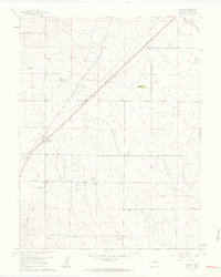
1961 Map of Falcon
USGS Topo · Published 1963About this map
The high plains landscape of El Paso County is defined by a distinct ranching economy and early transportation corridors in this early 1960s survey. The small settlement of Falcon serves as a central hub, situated near the intersection of major routes like the Falcon Highway and Burgess Road. The area is characterized by numerous family-named agricultural holdings, including the Old Brown Ranch, Bennett Ranch, and Nielsen Ranch, illustrating the legacy of land ownership in this part of Colorado.
Find a feature on this map
30 named features on this map. Tap any name to fly to it.
Don’t see what you’re looking for? This feature index may not catch every label — zoom into the map to look around manually.
Map Details
Editions of this 1961 Falcon Map
4 editions found
Other maps of this area

1893 · Big Springs
USGS Topo · 1:125,000

1893 · Colorado Springs
USGS Topo · 1:125,000

1894 · Castle Rock
USGS Topo · 1:125,000

1909 · Colorado Springs
USGS Topo · 1:125,000

1913 · Castle Rock
USGS Topo · 1:125,000

1940 · Elbert
USGS Topo · 1:62,500

1942 · Colorado Springs
USGS Topo · 1:125,000

1944 · Elbert
USGS Topo · 1:62,500

1948 · Falcon
USGS Topo · 1:24,000

1948 · Falcon
USGS Topo · 1:62,500