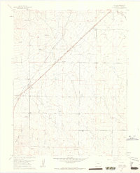
1961 Map of Falcon
USGS Topo · Published 1963About this map
The settlement of Falcon serves as the central hub of this 1961 survey, where the Chicago Rock Island and Pacific and the Colorado and Southern railroads intersect. This junction, established on the high plains east of Colorado Springs, defined the local economy during the mid-20th century. The surrounding landscape is characterized by a network of family-owned ranching operations, including the Old Brown Ranch, Bennett Ranch, and Nielsen Ranch, which are connected by a grid of named thoroughfares like Burgess Road and Judge Orr Road.
Find a feature on this map
32 named features on this map. Tap any name to fly to it.
Don’t see what you’re looking for? This feature index may not catch every label — zoom into the map to look around manually.
Map Details
Editions of this 1961 Falcon Map
4 editions found
Other maps of this area

1893 · Big Springs
USGS Topo · 1:125,000

1893 · Colorado Springs
USGS Topo · 1:125,000

1894 · Castle Rock
USGS Topo · 1:125,000

1909 · Colorado Springs
USGS Topo · 1:125,000

1913 · Castle Rock
USGS Topo · 1:125,000

1940 · Elbert
USGS Topo · 1:62,500

1942 · Colorado Springs
USGS Topo · 1:125,000

1944 · Elbert
USGS Topo · 1:62,500

1948 · Falcon
USGS Topo · 1:24,000

1948 · Falcon
USGS Topo · 1:62,500