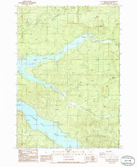
1986 Map of Fall Creek Lake
USGS Topo · Published 1986About this map
Fall Creek Lake and Lookout Point Lake dominate this mid-1980s landscape in the Willamette National Forest. The map documents a heavily managed forest and recreational environment, where infrastructure for leisure and resource extraction sits alongside the rising waters of the reservoirs. Locations like the Deer Ranch and the small settlement of Nelson provide evidence of local land use, while a network of service roads and a prominent Transmission Line trace the path of mid-century industrial development. Public access points are well-established, including Landax Landing County Park and Sky Camp, indicating the area's transition into a prime destination for timber-country recreation. Numerous peaks such as Bear Mountain, Mount Salem, and Fairview Mountain overlook the drainage basins of Winberry Creek and Norton Creek, showing the varied topography of the Cascades' western slopes.
Find a feature on this map
36 named features on this map. Tap any name to fly to it.
Don’t see what you’re looking for? This feature index may not catch every label — zoom into the map to look around manually.
Map Details
Editions of this 1986 Fall Creek Lake Map
This is the sole edition of this map. No revisions or reprints were ever made.
Other maps of this area

1935 · Lowell
USGS Topo · 1:96,000

1942 · Lowell
USGS Topo · 1:125,000

1950 · Marcola
USGS Topo · 1:62,500

1951 · Leaburg
USGS Topo · 1:62,500

1952 · Marcola
USGS Topo · 1:62,500

1953 · Salem
USGS Topo · 1:250,000

1954 · Salem
USGS Topo · 1:250,000

1955 · Hardesty Mtn
USGS Topo · 1:62,500

1955 · Lowell
USGS Topo · 1:62,500

1958 · Roseburg
USGS Topo · 1:250,000