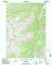
1991 Map of Fall Creek
USGS Topo · Published 1997About this map
Majo Ranch sits along the South Fork Shoshone River in this high-altitude corner of Northwest Wyoming, surveyed in 1991. The landscape is defined by the massive overlapping boundaries of the Shoshone National Forest, Teton National Forest, and the Washakie Wilderness. A notable point of historical industrial interest is the Sinkingwater Mining Region, located near the drainage of Needle Creek. This remote area relies on a network of watercourses like Cabin Creek and Silver Creek that carve through the terrain beneath Ash Mountain. The map also captures the administrative presence of the Wapiti Buffalo Ranger District, illustrating the management of these protected lands just before the turn of the twenty-first century.
Find a feature on this map
16 named features on this map. Tap any name to fly to it.
Don’t see what you’re looking for? This feature index may not catch every label — zoom into the map to look around manually.
Map Details
Editions of this 1991 Fall Creek Map
This is the sole edition of this map. No revisions or reprints were ever made.
Other maps of this area

1893 · Ishawooa
USGS Topo · 1:125,000

1895 · Ishawooa
USGS Topo · 1:125,000

1899 · Ishawooa
USGS Topo · 1:125,000

1905 · Younts Peak
USGS Topo · 1:125,000

1907 · Younts Peak
USGS Topo · 1:125,000

1955 · Cody
USGS Topo · 1:250,000

1955 · Thermopolis
USGS Topo · 1:250,000

1956 · Emerald Lake
USGS Topo · 1:24,000

1958 · Cody
USGS Topo · 1:250,000

1958 · Thermopolis
USGS Topo · 1:250,000