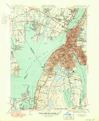
1944 Map of Fall River
USGS Topo · Published 1950About this map
Globe Village and the bustling industrial waterfront of the Taunton River anchor this mid-century portrait of the Massachusetts-Rhode Island borderlands. The map reveals an intensive urban landscape in the city of Fall River, where the Quequechan River feeds into the harbor near major transit arteries like the Brightman St Bridge and the New York New Haven and Hartford RR. This era of the city's history is marked by established neighborhoods centered around institutions like Diman Sch and numerous religious landmarks, including the Sacred Heart Convent and Blessed Sacrament Sch.
Find a feature on this map
102 named features on this map. Tap any name to fly to it.
Don’t see what you’re looking for? This feature index may not catch every label — zoom into the map to look around manually.
Map Details
Editions of this 1944 Fall River Map
4 editions found
Other maps of this area

1885 · Taunton
USGS Topo · 1:62,500

1887 · Providence
USGS Topo · 1:62,500

1888 · Fall River
USGS Topo · 1:62,500

1888 · Taunton
USGS Topo · 1:62,500

1889 · Providence
USGS Topo · 1:62,500

1890 · Narragansett Bay
USGS Topo · 1:62,500

1892 · Narragansett Bay
USGS Topo · 1:62,500

1893 · Taunton
USGS Topo · 1:62,500

1893 · Fall River
USGS Topo · 1:62,500

1894 · Providence
USGS Topo · 1:62,500