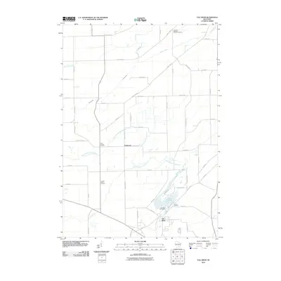
2010 Map of Fall River
USGS Topo · Published 2010About this map
Fall River and the crossroads of Englewood anchor this 2010 topographic record of Columbia County. The landscape is defined by the winding course of the North Branch Crawfish River, which widens significantly into Lazy Lake 61 near the Fall River 2WP73 Dam. The area’s rural heritage is well-preserved through several landmarks of interest to local historians and genealogists, including the Courtland Methodist Episcopal Cemetery in the north and Saint Stephen Cemetery situated along the river's western banks. Agricultural and residential life is structured around a network of county highways and local roads, such as Paradise Rd and Hyland Rd, while the northern reaches are drained by the upper stretches of Beaver Creek and Jennings Creek. This map offers a clear view of the modern layout of these small Wisconsin communities and their relationship to the local waterways.
Find a feature on this map
54 named features on this map. Tap any name to fly to it.
Don’t see what you’re looking for? This feature index may not catch every label — zoom into the map to look around manually.
Map Details
Editions of this 2010 Fall River Map
This is the sole edition of this map. No revisions or reprints were ever made.
Other maps of this area

1955 · Randolph
USGS Topo · 1:62,500

1955 · Columbus
USGS Topo · 1:62,500

1955 · Beaver Dam
USGS Topo · 1:62,500

1955 · Fox Lake
USGS Topo · 1:62,500

1957 · Madison
USGS Topo · 1:250,000

1960 · Madison
USGS Topo · 1:250,000

1980 · Fond Du Lac
USGS Topo · 1:100,000
1980 · North Bristol
USGS Topo · 1:24,000

1980 · Lost Lake
USGS Topo · 1:24,000
1980 · Columbus
USGS Topo · 1:24,000