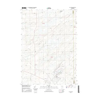
2016 Map of Fall River
USGS Topo · Published 2016About this map
Fall River serves as the focal point of this agricultural landscape in southern Wisconsin, situated where the North Br Crawfish River feeds into the expansive Lazy Lake. The village layout is defined by its proximity to the water, with Fall River Cem and various residential streets like Prairie St and Riverview Dr tracing the shoreline. The surrounding township of Fountain Prairie remains predominantly rural, characterized by a grid of country roads including Doylestown Rd and Paradise Rd. Cultural markers of the area's long-settled history are preserved in the numerous burial grounds scattered across the terrain, from the Saint Stephen Cem near the western edge to the Courtland Methodist Episcopal Cem in the north. The presence of the Fountain Prairie Airport on the southeastern outskirts reflects the modernization of this traditional farming region.
Find a feature on this map
62 named features on this map. Tap any name to fly to it.
Don’t see what you’re looking for? This feature index may not catch every label — zoom into the map to look around manually.
Map Details
Editions of this 2016 Fall River Map
This is the sole edition of this map. No revisions or reprints were ever made.
Other maps of this area

1955 · Randolph
USGS Topo · 1:62,500

1955 · Columbus
USGS Topo · 1:62,500

1955 · Beaver Dam
USGS Topo · 1:62,500

1955 · Fox Lake
USGS Topo · 1:62,500

1957 · Madison
USGS Topo · 1:250,000

1960 · Madison
USGS Topo · 1:250,000

1980 · Fond Du Lac
USGS Topo · 1:100,000
1980 · North Bristol
USGS Topo · 1:24,000

1980 · Lost Lake
USGS Topo · 1:24,000
1980 · Columbus
USGS Topo · 1:24,000