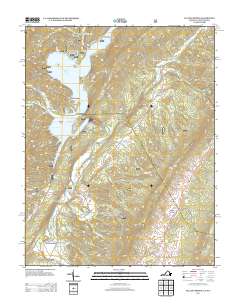
2013 Map of Falling Spring
USGS Topo · Published 2013About this map
Lake Moomaw dominates the western landscape of this Virginia-West Virginia borderland, where the Jackson River carves its way through steep ridges and hollows. The presence of The Gorge and features like Natural Well highlight the area's distinctive karst and riverine topography. Settlement is concentrated in the eastern valleys, with communities such as Carloover, Valley View, and Falling Spring clustered along the north-south transport corridor. Historical infrastructure is evident through numerous named crossings including Kelly Bridge, Smith Bridge, and Jenkins Ford. The region's role as a recreational destination is clear from the various facilities around the water, from Camp Appalachia to the Morris Hill Picnic Area and Bolar Mountain Campground.
Find a feature on this map
59 named features on this map. Tap any name to fly to it.
Don’t see what you’re looking for? This feature index may not catch every label — zoom into the map to look around manually.
Map Details
Editions of this 2013 Falling Spring Map
This is the sole edition of this map. No revisions or reprints were ever made.
Other maps of this area

1887 · Lewisburg
USGS Topo · 1:125,000

1891 · Lewisburg
USGS Topo · 1:125,000

1891 · Huntersville
USGS Topo · 1:125,000

1894 · Huntersville
USGS Topo · 1:125,000

1894 · Natural Bridge
USGS Topo · 1:125,000

1901 · Monterey
USGS Topo · 1:125,000

1921 · Callaghan
USGS Topo · 1:48,000

1923 · Marlinton
USGS Topo · 1:48,000

1923 · Warm Springs
USGS Topo · 1:48,000

1923 · Callaghan
USGS Topo · 1:62,500