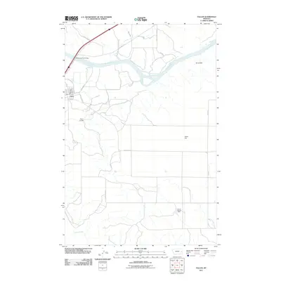
2011 Map of Fallon
USGS Topo · Published 2011About this map
The Yellowstone River snakes across this high plains landscape, defined by its wide valley and prominent northern overlooks at Barrs Bluffs. The settlement of Fallon serves as a small rail and road hub near the river crossing, where the Yellowstone River Bridge connects the local infrastructure to the Frontage HWY and N Railway Ave. This 2011 survey captures the town's essential services, including the Fallon Post Office and the Fallon Rural Fire Dist, which support the surrounding ranching and agricultural operations. To the south, the terrain opens into Fallon Flat, a broad expanse drained by the winding O'Fallon Creek and intermittent watercourses like Plum Coulee. Smaller tributaries such as Hatchet Creek feed into the main river channel, while the presence of the Saucer Number 1 Dam indicates the vital importance of water management in this arid Montana environment.
Find a feature on this map
23 named features on this map. Tap any name to fly to it.
Don’t see what you’re looking for? This feature index may not catch every label — zoom into the map to look around manually.
Map Details
Editions of this 2011 Fallon Map
This is the sole edition of this map. No revisions or reprints were ever made.
Other maps of this area

1953 · Miles City
USGS Topo · 1:250,000

1957 · Miles City
USGS Topo · 1:250,000

1958 · Miles City
USGS Topo · 1:250,000

1966 · Fallon
USGS Topo · 1:24,000

1966 · Marsh SW
USGS Topo · 1:24,000

1967 · Marsh
USGS Topo · 1:24,000
1967 · Fallon NE
USGS Topo · 1:24,000

1969 · Flat Top Butte
USGS Topo · 1:24,000

1969 · Flat Top Butte NE
USGS Topo · 1:24,000

1972 · Hendrickson Coulee
USGS Topo · 1:24,000