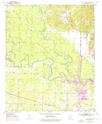
1950 Map of Falls Chapel
USGS Topo · Published 1976About this map
Cossatot River meanders sharply through the heart of this landscape, its tight oxbows defining the geography of the Sevier and Little River county line. The 1975 revisions illustrate a pivotal change in the regional hydrology with the appearance of Millwood Lake in the southeast, a development that altered the natural flow of the Little River. Near the northern heights of the map, the Paraclifta Monument stands as a marker of the area's early territorial history, situated just west of the Falls Chapel community.
Find a feature on this map
28 named features on this map. Tap any name to fly to it.
Don’t see what you’re looking for? This feature index may not catch every label — zoom into the map to look around manually.
Map Details
Editions of this 1950 Falls Chapel Map
2 editions found
Other maps of this area

1950 · Ashdown East
USGS Topo · 1:24,000

1950 · Ashdown West
USGS Topo · 1:24,000

1950 · Ben Lomond
USGS Topo · 1:24,000

1950 · Falls Chapel
USGS Topo · 1:24,000

1950 · Winthrop
USGS Topo · 1:24,000

1951 · Winthrop
USGS Topo · 1:24,000

1951 · Ben Lomond
USGS Topo · 1:24,000

1951 · Ashdown West
USGS Topo · 1:24,000

1951 · Falls Chapel
USGS Topo · 1:24,000

1951 · Ashdown East
USGS Topo · 1:24,000