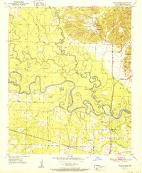
1951 Map of Falls Chapel
USGS Topo · Published 1951About this map
The Cossatot River and the Little River dominate this 1951 survey of the Arkansas borderlands, where the winding watercourses form the boundary between Sevier and Little River counties. The terrain is a complex of sloughs and oxbow lakes, including Red Lake and Davis Slough, illustrating the flood-prone nature of the bottomlands before modern interventions. Transportation history is deeply etched into the landscape, visible through the Kansas City Southern railroad line and an Old Railroad Grade that speaks to earlier timber or freight routes through the river bends.
Find a feature on this map
26 named features on this map. Tap any name to fly to it.
Don’t see what you’re looking for? This feature index may not catch every label — zoom into the map to look around manually.
Map Details
Editions of this 1951 Falls Chapel Map
2 editions found
Other maps of this area

1950 · Ashdown East
USGS Topo · 1:24,000

1950 · Ashdown West
USGS Topo · 1:24,000

1950 · Ben Lomond
USGS Topo · 1:24,000

1950 · Falls Chapel
USGS Topo · 1:24,000

1950 · Winthrop
USGS Topo · 1:24,000

1951 · Winthrop
USGS Topo · 1:24,000

1951 · Ben Lomond
USGS Topo · 1:24,000

1951 · Ashdown West
USGS Topo · 1:24,000

1951 · Falls Chapel
USGS Topo · 1:24,000

1951 · Ashdown East
USGS Topo · 1:24,000