
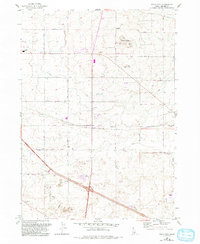
1964 Map of Falls City
USGS Topo · Published 1965About this map
Falls City sits at the heart of this mid-1960s agricultural and industrial landscape in Jerome County, anchored by the east-west line of the Union Pacific railroad. The era's transportation and communication infrastructure is well-defined, ranging from the County Airport in the northern section to the Radio Tower (KMVT) atop Flat Top Butte. Small settlements like Barrymore and Haytown are positioned along the rail corridor and secondary roads, reflecting the local settlement patterns of the Snake River Plain before modern expansion.
Find a feature on this map
31 named features on this map. Tap any name to fly to it.
Don’t see what you’re looking for? This feature index may not catch every label — zoom into the map to look around manually.
Map Details
Editions of this 1964 Falls City Map
2 editions found
Other maps of this area

1950 · Filer
USGS Topo · 1:24,000

1950 · Jerome
USGS Topo · 1:24,000

1950 · Jerome
USGS Topo · 1:62,500

1955 · Twin Falls
USGS Topo · 1:250,000

1958 · Twin Falls
USGS Topo · 1:250,000

1964 · Kimberly
USGS Topo · 1:24,000

1964 · Twin Falls
USGS Topo · 1:24,000

1964 · Perrine
USGS Topo · 1:24,000

1971 · Shoshone SE
USGS Topo · 1:24,000
1971 · Gooding SE
USGS Topo · 1:24,000