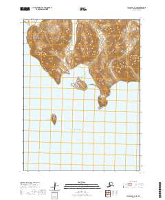
2020 Map of False Pass C-4 NW
USGS Topo · Published 2020About this map
Unimak Island serves as the focal point for this 2020 survey, where the terrestrial elevations of the Aleutian Islands meet the open waters of the Pacific Ocean. The geography is defined by prominent coastal summits including Ikatok Peak and Dora Peak, which overlook the southern reach of the Ikatan Peninsula. Along the jagged shoreline, the sheltered waters of Bora Harbor and Dora Harbor provide distinct maritime landmarks in an otherwise exposed coastal environment. South of the main island landmass, the isolated form of Bird Island rises from the sea, illustrating the fragmented volcanic nature of this remote archipelago. The topography is marked by steep relief and complex drainage patterns, reflecting the active geological processes inherent to this subarctic chain.
Find a feature on this map
13 named features on this map. Tap any name to fly to it.
Don’t see what you’re looking for? This feature index may not catch every label — zoom into the map to look around manually.
Map Details
Editions of this 2020 False Pass C-4 NW Map
This is the sole edition of this map. No revisions or reprints were ever made.
Other maps of this area

1949 · False Pass
USGS Topo · 1:250,000

1950 · False Pass
USGS Topo · 1:250,000
1989 · False Pass C-4
USGS Topo · 1:63,360
1989 · False Pass C-5
USGS Topo · 1:63,360
1995 · False Pass D-5
USGS Topo · 1:63,360
1995 · False Pass D-4
USGS Topo · 1:63,360

2020 · False Pass C-5 SE
USGS Topo · 1:25,000
2020 · False Pass C-5 NE
USGS Topo · 1:25,000
2020 · False Pass D-5 SE
USGS Topo · 1:25,000
2020 · False Pass D-4 SW
USGS Topo · 1:25,000