1991 Map of Faribault
USGS Topo · Published 1995About this map
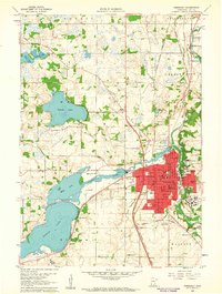
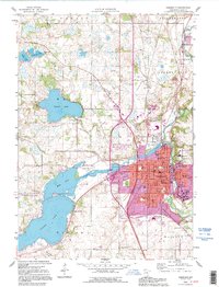
Faribault serves as a dense educational and institutional hub in this 1990s-era study, notable for its concentration of specialized schools and state facilities. The map highlights the Minnesota Sch for the Deaf, Braille Sch, and the sprawling State Hospital complex, reflecting a long-standing local history of public service and institutional development. The city's core is packed with historic landmarks including the Courthouse, Bethlehem Academy, and Shattuck Sch, nestled near the banks of the Cannon River.
Find a feature on this map
62 named features on this map. Tap any name to fly to it.
Don’t see what you’re looking for? This feature index may not catch every label — zoom into the map to look around manually.
Map Details
Editions of this 1991 Faribault Map
This is the sole edition of this map. No revisions or reprints were ever made.
Historical Maps of Faribault Through Time
8 maps found