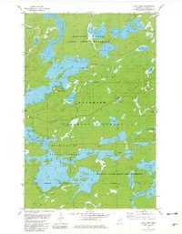
1981 Map of Farm Lake
USGS Topo · Published 1982About this map
Farm Lake and the surrounding wilderness of Lake County are defined by a complex network of interconnected waterways and portages as they appeared in the early 1980s. This survey illustrates the intricate boundary where the Superior National Forest meets the Boundary Waters Canoe Area Wilderness, showcasing a landscape largely preserved for recreation and natural resource management. Along the shores of Fall Lake, the Fall Lake Campground and various boat ramps indicate the importance of the region as a gateway for interior canoe travel.
Find a feature on this map
39 named features on this map. Tap any name to fly to it.
Don’t see what you’re looking for? This feature index may not catch every label — zoom into the map to look around manually.
Map Details
Editions of this 1981 Farm Lake Map
2 editions found
Other maps of this area

1933 · Ely
USGS Topo · 1:62,500

1939 · Ely
USGS Topo · 1:62,500

1954 · Two Harbors
USGS Topo · 1:250,000

1957 · Two Harbors
USGS Topo · 1:250,000

1957 · Gabbro Lake
USGS Topo · 1:62,500

1957 · Basswood Lake
USGS Topo · 1:62,500

1957 · Quetico
USGS Topo · 1:250,000

1958 · Two Harbors
USGS Topo · 1:250,000

1963 · Fourtown Lake
USGS Topo · 1:24,000

1964 · Two Harbors
USGS Topo · 1:250,000