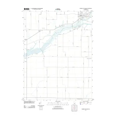
2012 Map of Farmer City South
USGS Topo · Published 2012About this map
Farmer City anchors the northeastern corner of this DeWitt County landscape, where the southern reaches of the town meet the wetlands surrounding Salt Cr. The map reveals a transition from organized municipal streets to the vast agricultural grid that characterizes Central Illinois. To the west, the infrastructure of the Parnell Oil Field near the settlement of Parnell indicates the local extraction industry, while the sprawling waters of Lake Clinton dominate the southwestern portion of the quadrangle. Several distinct burial grounds are scattered throughout the countryside, including McCord Cem, Barnes Cem, and Greenleaf Cem, which serve as vital markers for genealogical research in this rural region. The presence of Weidner Landing Field in the east and the small rail-aligned settlement of Fullerton further illustrate the varied transportation and land-use patterns of the early twenty-first century.
Find a feature on this map
70 named features on this map. Tap any name to fly to it.
Don’t see what you’re looking for? This feature index may not catch every label — zoom into the map to look around manually.
Map Details
Editions of this 2012 Farmer City South Map
This is the sole edition of this map. No revisions or reprints were ever made.
Other maps of this area

1937 · Monticello
USGS Topo · 1:48,000

1943 · Monticello
USGS Topo · 1:62,500

1951 · Le Roy
USGS Topo · 1:62,500

1952 · Arrowsmith
USGS Topo · 1:62,500

1957 · Maroa
USGS Topo · 1:62,500

1958 · Peoria
USGS Topo · 1:250,000

1961 · Peoria
USGS Topo · 1:250,000

1963 · Peoria
USGS Topo · 1:250,000

1979 · De Witt
USGS Topo · 1:24,000
1979 · Monticello
USGS Topo · 1:24,000