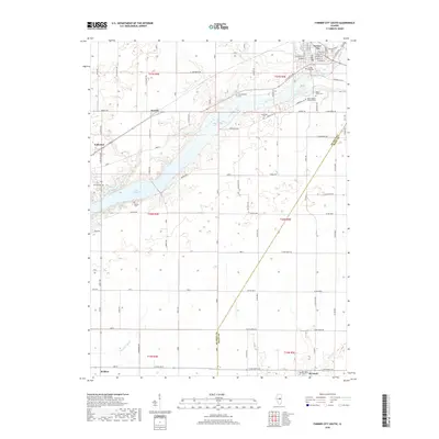
2018 Map of Farmer City South
USGS Topo · Published 2018About this map
Farmer City occupies the northeastern corner of this landscape, where a dense grid of streets like W Market St and E Clinton Ave transitions into the productive agricultural lands of Central Illinois. The southern reach of Lake Clinton dominates the western half of the map, a modern reservoir that has significantly altered the local drainage patterns formerly defined by Salt Creek. The survey area is notably dense with small rural burial grounds, providing a significant resource for genealogical research. These sites, including Campground Cem and Greenleaf Cem, are scattered across the township lines of t21n r4e and t20n r5e. Along the southern border, the community of Weldon and the northern edge of De Land sit amidst a network of drainage features like Goose Cr and Friends Cr Ditch.
Find a feature on this map
85 named features on this map. Tap any name to fly to it.
Don’t see what you’re looking for? This feature index may not catch every label — zoom into the map to look around manually.
Map Details
Editions of this 2018 Farmer City South Map
This is the sole edition of this map. No revisions or reprints were ever made.
Other maps of this area

1937 · Monticello
USGS Topo · 1:48,000

1943 · Monticello
USGS Topo · 1:62,500

1951 · Le Roy
USGS Topo · 1:62,500

1952 · Arrowsmith
USGS Topo · 1:62,500

1957 · Maroa
USGS Topo · 1:62,500

1958 · Peoria
USGS Topo · 1:250,000

1961 · Peoria
USGS Topo · 1:250,000

1963 · Peoria
USGS Topo · 1:250,000

1979 · De Witt
USGS Topo · 1:24,000
1979 · Monticello
USGS Topo · 1:24,000