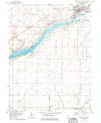
1979 Map of Farmer City South
USGS Topo · Published 1980About this map
Lake Clinton dominates the central landscape of this late-1970s survey, its waters filling the valley of Salt Creek across De Witt and Piatt counties. This era of transformation is captured just as the reservoir altered the local topography, yet the map preserves the older rural patterns of the Blue Ridge region. To the north, Farmer City serves as a primary hub, intersected by Conrail lines and residential growth near the Golf Course.
Find a feature on this map
36 named features on this map. Tap any name to fly to it.
Don’t see what you’re looking for? This feature index may not catch every label — zoom into the map to look around manually.
Map Details
Editions of this 1979 Farmer City South Map
This is the sole edition of this map. No revisions or reprints were ever made.
Other maps of this area

1937 · Monticello
USGS Topo · 1:48,000

1943 · Monticello
USGS Topo · 1:62,500

1951 · Le Roy
USGS Topo · 1:62,500

1952 · Arrowsmith
USGS Topo · 1:62,500

1957 · Maroa
USGS Topo · 1:62,500

1958 · Peoria
USGS Topo · 1:250,000

1961 · Peoria
USGS Topo · 1:250,000

1963 · Peoria
USGS Topo · 1:250,000

1979 · De Witt
USGS Topo · 1:24,000
1979 · Monticello
USGS Topo · 1:24,000