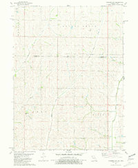
1981 Map of Farmers City
USGS Topo · Published 1981About this map
The Missouri-Iowa state line bisects this agricultural landscape, where the border between Fremont County and Atchison County follows the same path. The drainage patterns of the Loess Hills define the terrain, with Mill Creek, High Creek, and West High Creek flowing through the western sections of Madison and Polk townships. Centrally located, the small settlement of Farmers City serves as a local landmark amidst a network of rural roads and scattered houses of worship, including Locust Grove Ch and St Pauls Ch. This 1981 survey documents the late 20th-century rural infrastructure before modern consolidation changed many such crossroads communities. Genealogists may find value in the location of Grange Hall Cem and St Johns Ch, while the course of West Tarkio Creek and Rock Creek illustrates the intricate hydrology of Lincoln and Locust Grove townships.
Find a feature on this map
16 named features on this map. Tap any name to fly to it.
Don’t see what you’re looking for? This feature index may not catch every label — zoom into the map to look around manually.
Map Details
Editions of this 1981 Farmers City Map
This is the sole edition of this map. No revisions or reprints were ever made.
Other maps of this area

1915 · Nemaha
USGS Topo · 1:62,500

1939 · Tarkio
USGS Topo · 1:62,500

1939 · Farragut
USGS Topo · 1:62,500

1939 · Hamburg
USGS Topo · 1:62,500

1939 · Nemaha
USGS Topo · 1:62,500

1940 · Tarkio
USGS Topo · 1:62,500

1940 · Farragut
USGS Topo · 1:62,500

1941 · Tarkio
USGS Topo · 1:62,500

1941 · Hamburg
USGS Topo · 1:62,500

1949 · Nemaha
USGS Topo · 1:62,500