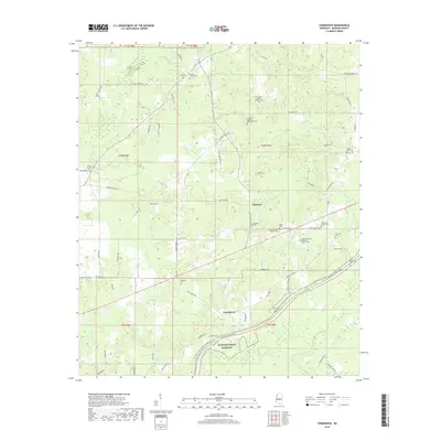
2018 Map of Farmhaven
USGS Topo · Published 2018About this map
Dancing Rabbit Cr and its tributaries define the rural geography of this Madison County landscape, where small communities like Farmhaven and Raytown are anchored by deep-rooted family and congregational sites. The map reveals a dense network of local cemeteries, including the Old Sulphur Springs Catholic Cem and Sulphur Springs Methodist Cem, reflecting the early religious settlement patterns of the region. The southern portion of the quadrangle is bisected by the Natchez Trace Parkway, which follows the historic corridor of the Natchez Trace National Scenic Trail. Numerous family-named roads, such as Ben Luckett Rd and Pat Luckett Rd, suggest a landscape shaped by generational landownership, providing a clear window into the local genealogy of Lottville and the surrounding countryside.
Find a feature on this map
74 named features on this map. Tap any name to fly to it.
Don’t see what you’re looking for? This feature index may not catch every label — zoom into the map to look around manually.
Map Details
Editions of this 2018 Farmhaven Map
This is the sole edition of this map. No revisions or reprints were ever made.
Other maps of this area

1953 · Meridian
USGS Topo · 1:250,000

1957 · Meridian
USGS Topo · 1:250,000

1960 · Sharon
USGS Topo · 1:62,500

1961 · Carthage
USGS Topo · 1:62,500

1962 · Thomastown
USGS Topo · 1:62,500

1964 · Camden
USGS Topo · 1:24,000

1965 · Meridian
USGS Topo · 1:250,000
1966 · Goodman
USGS Topo · 1:62,500

1984 · Carthage
USGS Topo · 1:100,000
1988 · Sharon
USGS Topo · 1:24,000