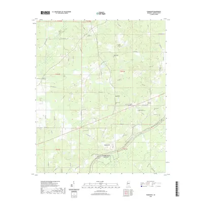
2020 Map of Farmhaven
USGS Topo · Published 2020About this map
Farmhaven and Raytown anchor this central Madison County landscape, where the historic corridor of the Natchez Trace Pkwy and the Natchez Trace National Scenic Trail cut diagonally through the southern terrain. This modern survey reveals a dense network of family and community landmarks, particularly evident in the concentration of cemeteries such as Eugene Garrett Memorial Garden Cem and Old Sulphur Springs Catholic Cem. The drainage patterns are defined by several winding waterways, including Dancing Rabbit Cr and Doaks Cr, which flow through a countryside largely shaped by rural road networks like Sulphur Springs Rd and Virgin Mary Rd. The presence of numerous small congregational sites, including the Truelight Mission Baptist Cem and Sulphur Springs Methodist Cem, speaks to the long-standing community foundations of the region.
Find a feature on this map
82 named features on this map. Tap any name to fly to it.
Don’t see what you’re looking for? This feature index may not catch every label — zoom into the map to look around manually.
Map Details
Editions of this 2020 Farmhaven Map
This is the sole edition of this map. No revisions or reprints were ever made.
Other maps of this area

1953 · Meridian
USGS Topo · 1:250,000

1957 · Meridian
USGS Topo · 1:250,000

1960 · Sharon
USGS Topo · 1:62,500

1961 · Carthage
USGS Topo · 1:62,500

1962 · Thomastown
USGS Topo · 1:62,500

1964 · Camden
USGS Topo · 1:24,000

1965 · Meridian
USGS Topo · 1:250,000
1966 · Goodman
USGS Topo · 1:62,500

1984 · Carthage
USGS Topo · 1:100,000
1988 · Sharon
USGS Topo · 1:24,000