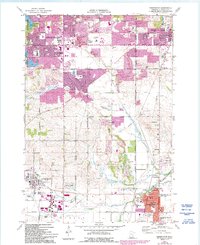
1974 Map of Farmington
USGS Topo · Published 1993About this map
Apple Valley, Rosemount, and Lakeville appear during a period of rapid suburban transformation in the mid-1970s. The landscape is defined by its evolving corporate boundaries and a grid of rural routes like Pilot Knob Road and Dodd Road that began to frame new residential developments. In the southern portion of the map, Farmington maintains its established character, centered around the County Fairground and the Vermillion River.
Find a feature on this map
74 named features on this map. Tap any name to fly to it.
Don’t see what you’re looking for? This feature index may not catch every label — zoom into the map to look around manually.
Map Details
Editions of this 1974 Farmington Map
2 editions found
Other maps of this area

1896 · Minneapolis
USGS Topo · 1:62,500

1896 · St. Paul
USGS Topo · 1:62,500

1901 · Minneapolis
USGS Topo · 1:62,500

1951 · Inver Grove
USGS Topo · 1:24,000

1951 · St. Paul SW
USGS Topo · 1:24,000

1951 · St. Paul
USGS Topo · 1:62,500

1953 · Saint Paul
USGS Topo · 1:250,000

1954 · Bloomington
USGS Topo · 1:24,000

1954 · Minneapolis
USGS Topo · 1:62,500

1957 · Farmington
USGS Topo · 1:62,500