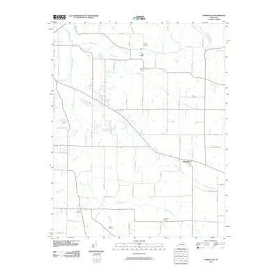
2010 Map of Farmington
USGS Topo · Published 2010About this map
Farmington serves as the central hub of this Graves County landscape, situated at a major rural junction south of the modern State Route 121 bypass. The area is defined by an intricate network of waterways, with Mayfield Creek and its many tributaries, including Little Mayfield Creek and Vulton Creek, carving a pattern across the countryside. This drainage network influenced the placement of early homesteads and transportation routes, many of which are identified by family-named roads like Puryear Rd, Dave Miller Rd, and Jacks Rd.
Find a feature on this map
60 named features on this map. Tap any name to fly to it.
Don’t see what you’re looking for? This feature index may not catch every label — zoom into the map to look around manually.
Map Details
Editions of this 2010 Farmington Map
This is the sole edition of this map. No revisions or reprints were ever made.
Other maps of this area

1936 · Farmington
USGS Topo · 1:24,000

1936 · Oak Level
USGS Topo · 1:24,000

1936 · Lynn Grove
USGS Topo · 1:24,000

1936 · Benton
USGS Topo · 1:48,000

1936 · Westplains
USGS Topo · 1:24,000

1936 · Kirksey
USGS Topo · 1:24,000

1951 · Kirksey
USGS Topo · 1:24,000

1951 · Farmington
USGS Topo · 1:24,000
1951 · Oak Level
USGS Topo · 1:24,000

1951 · Hickory
USGS Topo · 1:24,000