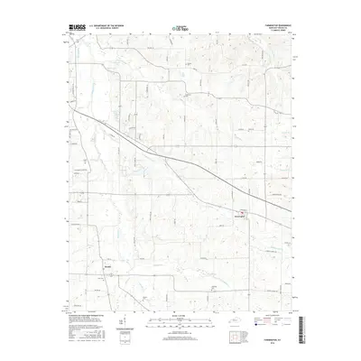
2016 Map of Farmington
USGS Topo · Published 2016About this map
Sedalia and Farmington anchor this rural landscape in Graves County, where the terrain is defined by a dense network of watercourses including Mayfield Creek and Little Mayfield Cr. The settlement pattern follows established corridors like Jeff Davis Rd and Claude Rd, which bisect the undulating topography. Genealogists will find significant value in the distribution of family and community burial grounds, such as Torian Cem, Hendon Cem, and Yarbrough Cem, which are scattered throughout the agricultural tracts. The presença of Sutherland Lake and Foster Pond indicates local water management and recreation within a region dominated by small-scale farming and road networks. The intricate drainage system, featuring Vulton Cr, Kess Cr, and Bacon Cr, reveals the natural hydrology that has dictated land use and property boundaries in this part of Kentucky for generations.
Find a feature on this map
76 named features on this map. Tap any name to fly to it.
Don’t see what you’re looking for? This feature index may not catch every label — zoom into the map to look around manually.
Map Details
Editions of this 2016 Farmington Map
This is the sole edition of this map. No revisions or reprints were ever made.
Other maps of this area

1936 · Farmington
USGS Topo · 1:24,000

1936 · Oak Level
USGS Topo · 1:24,000

1936 · Lynn Grove
USGS Topo · 1:24,000

1936 · Benton
USGS Topo · 1:48,000

1936 · Westplains
USGS Topo · 1:24,000

1936 · Kirksey
USGS Topo · 1:24,000

1951 · Kirksey
USGS Topo · 1:24,000

1951 · Farmington
USGS Topo · 1:24,000
1951 · Oak Level
USGS Topo · 1:24,000

1951 · Hickory
USGS Topo · 1:24,000